Mexican Territory Historical Maps: A Journey Through Time
Imagine tracing the shifting borders of Mexico, a nation whose geographic footprint has been dramatically reshaped by centuries of conflict, negotiation, and shifting political tides. This isn't just a story of lines on a map; it's a narrative woven from wars, treaties, and the enduring struggle for national identity. Using historical maps, we'll explore the fascinating evolution of Mexico's territory, revealing the powerful forces that sculpted its current form. For additional visual resources, check out this old Mexico map.
The Colonial Era: A Sketch of an Empire
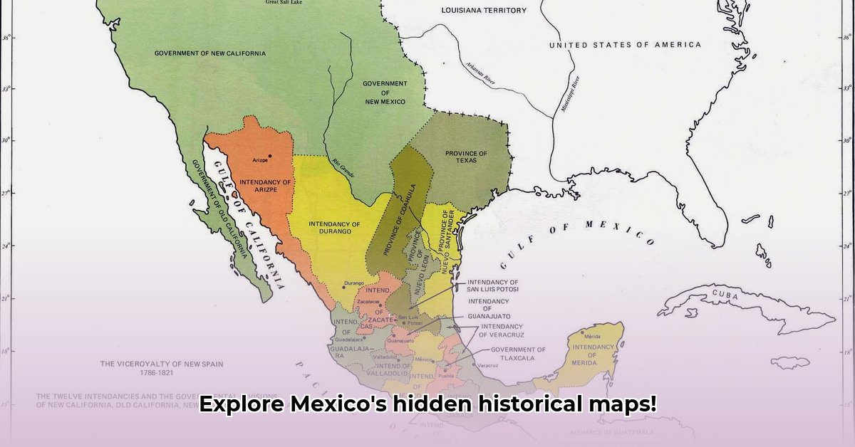
Early maps of New Spain (16th-18th centuries) depict a vast territory, far exceeding modern-day Mexico's boundaries. These maps, often imprecise by today's standards, reflect the gradual expansion of Spanish colonial power. They're not just geographical representations; they illustrate the ambition and reach of a far-off empire, slowly asserting control over a diverse population and rich resources. Ambiguities and overlapping claims were common; precise borders were often a matter of ongoing debate and, in many cases, military conquest. Did you know that the initial Spanish claims were far more extensive than the eventual established borders?
Independence and the Early Republic: A Nation in Flux
Mexican independence in 1821 didn’t magically solidify borders. The newly independent nation inherited a legacy of internal conflicts and border disputes. Maps from this era (early 19th century) show shifting internal divisions, mirroring the volatile political landscape. Centralist and federalist governments battled for control, resulting in constantly changing state boundaries. This instability is vividly reflected in the inconsistent and sometimes conflicting boundary lines depicted on the maps of this period. How did these internal conflicts contribute to the later vulnerability of Mexico's northern territories?
The Mexican-American War: A Defining Loss and a Redrawn Map
The Mexican-American War (1846-1848) marked a watershed moment. The Treaty of Guadalupe Hidalgo (1848) resulted in the loss of approximately half of Mexico's pre-war territory to the United States. Maps from this period starkly illustrate this territorial cession, a defining moment in Mexico's history. The lines on these maps aren't merely geographic divisions; they represent a profound shift in national identity and geopolitical standing. What lasting impact did this territorial loss have on Mexican national identity and future development?
The Porfiriato: Order on the Surface, Tensions Beneath
Porfirio Díaz's long reign (1876-1911), the Porfiriato, brought a period of relative stability, resulting in seemingly clearer border definitions. However, this outward stability masked deep social and economic inequalities. Maps from this era showcase a nation striving for an image of progress, yet grappling with unresolved historical tensions. The apparent order on the map belied the underlying social unrest that would erupt into the Mexican Revolution. How did the political stability of the Porfiriato affect the clarity of Mexico's borders, and what underlying tensions remained?
The 20th and 21st Centuries: Refinement and Ongoing Issues
The 20th and 21st centuries witnessed far fewer dramatic border changes than the previous century. Maps from this period show a nation focused on consolidating its identity and resolving smaller, localized border disputes. While the massive territorial losses of the past weren't reversed, the focus shifted from large-scale conflicts to more nuanced negotiations and clarifications. Nevertheless, some border disputes persist to this day. How have evolving international relations and economic agreements influenced border management in the 20th and 21st centuries?
Decoding the Maps: More Than Just Lines
Historical maps are more than just geographical representations; they reveal the biases and perspectives of their creators. What details did mapmakers choose to highlight or omit? How did their political viewpoints influence the depiction of borders and settlements? Analyzing these inconsistencies helps us understand the complexities of historical narratives and the multiple interpretations that can be drawn from seemingly objective sources. What can the analysis of cartographic techniques and the choices made by mapmakers tell us about the historical context and power dynamics of the time?
Key Factors Shaping Mexico's Borders: A Complex Interplay
The evolution of Mexico's borders wasn't determined by a single factor. It was a complex interaction of several forces:
- Political Instability: Frequent border revisions, internal conflicts, and territorial disputes directly resulted from unstable political climates.
- External Pressures: Loss of territory, foreign influence in border negotiations, and imposed treaties profoundly altered Mexico's geographic boundaries.
- Legal Frameworks: Varying interpretations of treaties and ambiguous boundary definitions led to long-standing disputes.
- Geographic Features: While natural features often formed boundaries, their shifting nature caused further ambiguity and conflict.
- Ideological Shifts: Conflicts between centralist and federalist ideologies influenced internal boundaries and administrative structures.
Mexican Territory Historical Maps provide invaluable insights into the complex history of Mexico. They are visual narratives that reflect power dynamics, compromises, and the enduring struggle to define the nation's identity and place within the world. Further research into the maps' creators, their methodologies, and the political context of their creation will provide even deeper understanding.
How did fluctuating political ideologies impact Mexico's border changes after independence?
Key Takeaways:
- Post-independence Mexico experienced immense border instability due to internal conflict and external pressures.
- Fluctuating political ideologies, particularly the struggle between centralist and federalist factions, profoundly impacted territorial integrity and boundary negotiations.
- Historical maps are crucial tools for understanding these complex border changes, illustrating not just geographical shifts but also the underlying political struggles.
- Analyzing these shifts offers valuable insights into the evolution of Mexico’s identity and its relationship with its neighbors.
The Early Years: Instability and Territorial Disputes
Mexico's independence did not bring immediate border stability. Internal conflicts between centralists and federalists heavily influenced territorial integrity, often leading to civil wars and power struggles that directly impacted border demarcation. Disputes over territories like Texas escalated due to conflicting legal interpretations and political ambitions. What were the primary sources of conflict between centralist and federalist factions in the early years of Mexican independence, and how did these ideological clashes affect border stability?
The Mexican-American War and its Aftermath (1846-1848)
The Mexican-American War was a clash of ideologies—Manifest Destiny against Mexico's struggle for territorial integrity. The Treaty of Guadalupe Hidalgo resulted in massive territorial losses, dramatically altering Mexico's geopolitical landscape and fueling lasting resentment towards the United States. How did the concept of "Manifest Destiny" influence the outcome of the Mexican-American War and the subsequent redrawing of Mexico's borders?
The Porfiriato and the Search for Stability (1876-1911)
Porfirio Díaz's rule brought relative political stability but also masked deep social and economic inequalities. His focus on economic growth sometimes overshadowed border security concerns, inadvertently contributing to further American influence in the northern regions. How did Porfirio Díaz’s authoritarian modernist ideology contribute to the maintenance and appearance of border stability during the Porfiriato era?
The 20th and 21st Centuries: Ongoing Evolution
The 20th and 21st centuries saw further border shifts. The Mexican Revolution again led to internal turmoil, while economic agreements like NAFTA profoundly altered border landscapes. These changes, stemming from evolving political ideologies, profoundly shaped life along the border. What are some of the prominent economic and social factors influencing Mexico’s border policies in the 20th and 21st centuries?